![](/images/other/stat-length.png)
![Tour Wandern La Grave - 2020-09-03 Marche La Grave au Refuge du Pic du Mas de la Grave - Photo](https://media.geolcdn.com/t/1900/400/47845ef7-2166-466b-bb9f-8b90b012e6e1.jpg&format=pjpeg&maxdim=2)
2020-09-03 Marche La Grave au Refuge du Pic du Mas de la Grave
holtzv
Benutzer GUIDE
![Länge](/images/other/stat-length.png)
![Maximale Höhe](https://static1.geolcdn.com/siteimages/upload/files/1508320355ic_sort_altitude_max_24dp.png)
![Positive Höhendifferenz](https://static1.geolcdn.com/siteimages/upload/files/1508320355ic_sort_den_pos_24dp.png)
![Km-Effort](/images/other/stat-length.png)
![Min. Höhe](https://static1.geolcdn.com/siteimages/upload/files/1508320355ic_sort_altitude_min_24dp.png)
![Negative Höhendifferenz](https://static1.geolcdn.com/siteimages/upload/files/1508320355ic_sort_den_neg_24dp.png)
![Boucle](https://static1.geolcdn.com/siteimages/upload/files/16400158638029165_repeat_loop_refresh_sync_direction_icon.png)
![Wandern](https://static1.geolcdn.com/sitytour/trail-icons/101.png)
4h58
Schwierigkeit : Sehr leicht
![Scannen Sie diesen QR-Code, um die Tour in der SityTrail-Anwendung zu öffnen](https://capi.geolives.com/qq0zvz2zws4bq2lad0pu/sitytour/trails/2546888/qr.png?size=200)
Kostenlosegpshiking-Anwendung
Über SityTrail
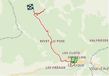
Tour Wandern von 12,2 km verfügbar auf Provence-Alpes-Côte d'Azur, Hochalpen, La Grave. Diese Tour wird von holtzv vorgeschlagen.
Beschreibung
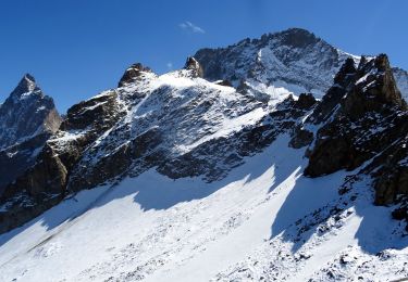
Au départ du village de la Grave, on emprunte le GR50-54 pour rejoindre les village les Terrasses et le Chazelet avec une magnifique vue sur la Meije mais aussi sur les passages des prochains jours. En poursuivant sur un chemin forestier dans le vallon de la Gâ, on rejoint le refuge du Pic du Mas de la Grave (alt 1940m), entièrement refait en 2016.
Ort
Kommentare
Touren in der Umgebung
![Tour Wandern Villar-d'Arêne - L'Aiguillon et Lac du Pontet 28.8.22 - Photo](https://media.geolcdn.com/t/375/260/007e50a5-b3c9-4529-9bf1-1ab760d39579.jpg&format=jpg&maxdim=2)
![Wandern Wandern](https://static1.geolcdn.com/sitytour/trail-icons/101.png)
Wandern
![](/images/other/stat-length.png)
![](https://static1.geolcdn.com/siteimages/upload/files/16400158638029165_repeat_loop_refresh_sync_direction_icon.png)
![Tour Wandern La Grave - L'aiguille du Goléon - Photo](https://media.geolcdn.com/t/375/260/ext.jpg?maxdim=2&url=https%3A%2F%2Fservices.sitytrail.com%2FGeolivesWS%2FDownloadMedia.ashx%3FTrailID%3D101222%26Media%3D710_2.jpg)
![Wandern Wandern](https://static1.geolcdn.com/sitytour/trail-icons/101.png)
Wandern
![](/images/other/stat-length.png)
![](https://static1.geolcdn.com/siteimages/upload/files/16400158638029165_repeat_loop_refresh_sync_direction_icon.png)
![Tour Wandern La Grave - 05 lac goleon - Photo](https://media.geolcdn.com/t/375/260/abf8f99e-f4a4-42bd-8090-69a0a4a7cd63.jpg&format=jpg&maxdim=2)
![Wandern Wandern](https://static1.geolcdn.com/sitytour/trail-icons/101.png)
Wandern
![](/images/other/stat-length.png)
![](https://static1.geolcdn.com/siteimages/upload/files/16400158638029165_repeat_loop_refresh_sync_direction_icon.png)
![Tour Wandern La Grave - 05 refuge e chancel - Photo](https://media.geolcdn.com/t/375/260/e45ae6e7-d20c-4652-ac11-0baa8b6d8886.jpg&format=jpg&maxdim=2)
![Wandern Wandern](https://static1.geolcdn.com/sitytour/trail-icons/101.png)
Wandern
![](/images/other/stat-length.png)
![](https://static1.geolcdn.com/siteimages/upload/files/16400158638029165_repeat_loop_refresh_sync_direction_icon.png)
![Tour Wandern La Grave - vallons de la Meije : lac Puy Vachère - Photo](https://media.geolcdn.com/t/375/260/67d29b46-abdb-45ba-9c3a-55e84b743ed6.jpg&format=jpg&maxdim=2)
![Wandern Wandern](https://static1.geolcdn.com/sitytour/trail-icons/101.png)
Wandern
![](/images/other/stat-length.png)
![](https://static1.geolcdn.com/siteimages/upload/files/16400158638029165_repeat_loop_refresh_sync_direction_icon.png)
![Tour Zu Fuß La Grave - Le Chazelet - Refuge du Pic du Mas de la Grave en boucle - Photo](https://media.geolcdn.com/t/375/260/52a9a626-d23a-47b8-b762-a5eff72b3bed.jpg&format=jpg&maxdim=2)
![Zu Fuß Zu Fuß](https://static1.geolcdn.com/sitytour/trail-icons/100.png)
Zu Fuß
![](/images/other/stat-length.png)
![](https://static1.geolcdn.com/siteimages/upload/files/16400158638029165_repeat_loop_refresh_sync_direction_icon.png)
![Tour Wandern Villar-d'Arêne - SityTrail - Lac du pontet et l'Aiguillon - Photo](https://media.geolcdn.com/t/375/260/ext.jpg?maxdim=2&url=https%3A%2F%2Fstatic1.geolcdn.com%2Fsiteimages%2Fupload%2Ffiles%2F1553511878bg_sport_marche.png)
![Wandern Wandern](https://static1.geolcdn.com/sitytour/trail-icons/101.png)
Wandern
![](/images/other/stat-length.png)
![](https://static1.geolcdn.com/siteimages/upload/files/16400158638029165_repeat_loop_refresh_sync_direction_icon.png)
![Tour Wandern La Grave - 2020-09-03 Marche Tour de la Grave au plateau d'Emparis par le Pic du Mas de la Grave (3 jours) - Photo](https://media.geolcdn.com/t/375/260/db3fb938-b4cb-4c23-b152-eb22bce76ff5.jpg&format=jpg&maxdim=2)
![Wandern Wandern](https://static1.geolcdn.com/sitytour/trail-icons/101.png)
Wandern
![](/images/other/stat-length.png)
![](https://static1.geolcdn.com/siteimages/upload/files/16400158638029165_repeat_loop_refresh_sync_direction_icon.png)
![Tour Wandern La Grave - 2020-09-06 Marche La Grave Gare de Peyrou d'Amont au Col des Ruillans - Photo](https://media.geolcdn.com/t/375/260/a3c985ae-cb99-452b-95ca-e622fb85b5fb.jpg&format=jpg&maxdim=2)
![Wandern Wandern](https://static1.geolcdn.com/sitytour/trail-icons/101.png)
Wandern
![](/images/other/stat-length.png)
![](https://static1.geolcdn.com/siteimages/upload/files/16400158638029165_repeat_loop_refresh_sync_direction_icon.png)